The Central Africa Forest Observatory (OFAC) was created to ensure information availability to support sustainable forest ecosystem management in Central Africa.
Along with its partners, OFAC has introduced various environmental data monitoring and collection systems. These tools have enabled reports like The State of the
Forests and The State of the Protected Areas, as well as online databases for the public.
Download the OFAC indicator booklet
Alongside these monitoring systems, an interface has been developed to provide geographic data, downloadable via a geographic data repository,
allowing individuals to make their own maps.
Collecting at national level
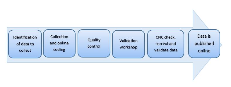
Every year, OFAC organizes a campaign to collect reference data called ‘monitoring indicators’ in the 10 COMIFAC countries.
These indicators, first defined in 2008, were selected because of their relevance, the nature of the variables, and the ease of collection.
They are revised regularly to factor in emerging issues and to ensure synergy with the other regional mechanisms for collecting environmental data in Central Africa, e.g. the FAO FRA (forest resources assessment) or the ITTO biannual data drives.
The collected monitoring indicators, look at five topics:
(i) forest cover,
(ii) legal and judicial framework,
(iii) forest management,
(iv) the conservation and enhancement of biodiversity,and
(v) the climate change.
Collection of these monitoring indicators is organized by National Groups, composed of Focal Points (members of ministries and administrations responsible for the data being collected) and a Main Correspondent, the country’s National COMIFAC Coordinator.
The regional and national indicators have been approved by representatives of
the different groups directly regional and national indicatorsor indirectly involved in forest management in Central Africa.
For each type of indicator and each level of analysis (regional, national, concession), data collection sheets are created by the regional unit of the FORAF (African Forests) project,
and distributed to project contacts in the six countries of the sub-region. Data currently online was collected in 2008.
The regional forest management monitoring indicators are classified into eight categories:
- Economic data for the forestry sector
- Forest statistics and trends
- Sustainable management in industrial forest concessions
- Community forest management
- Short-term forest permits
- Industrial wood processing
- Forest plantations
- Informal logging.
More on regional indicators
National monitoring indicators on forest management are classified into 9 categories: the 8 categories above, and «Management of communal forests».
More on national indicators
National indicators are collected from government administrations, as well as through ‘collection workshops’ attended by experts from all participating
countries. After data is collected, the OFAC team checks for accuracy to ensure consistency over time and to correct any obvious mistakes.
The National Group then holds a validation workshop where experts discuss, validate or, if needed, revise the received data.
Following this workshop, once the Main Correspondent has uploaded and checked the data online, it is published on the OFAC website and available
for all to use. This data provides input for national and regional summary notes, theme-specific notes and other OFAC publications.
Collecting in designated sites
Forest concessions
Together, OFAC and its partners have set up a monitoring database for forest concessions, in order to compile data from all forestry operations in the COMIFAC countries. Monitoring indicators cover:
- General information : on the concession (description, type of permit, date and duration of allocation, etc), on the company, and on the area in question
- Management and operations : management process and annual production statistics
- Social aspects : socio-economic studies, social environment around the operation site, actions towards employees and local populations
- Biodiversity : state of biodiversity in the concession, identification of pressure points, biodiversity management strategy
More on concession-level monitoring indicators
Alongside these monitoring indicators, OFAC is introducing a series of tools to monitor forestry operations across Central Africa::
- Monitoring concessions and logging: monitoring forest logging trails/roads and density through satellite imagery; on-the-ground monitoring of volunteer concessions using collaboratively chosen indicators
- Monitoring the wood industry: using a set of technical and economic indicators (e.g. material yield rates, number of species exploited, percentage of mechanically dried sawn timber).
- Monitoring informal small-scale operations: annual estimation of quantity of wood used by the informal sector, based on information provided by an observation network across timber depots in major cities
- Typology of illegal timber operations: inventory and classification of illegal logging cases using an analysis grid; impact of illegal logging on the environment and conflicts; analysis of norms and their impact on the development of illegal logging; match between estimated potential for sustainable production and developing demand for timber within the countries.
Protected areas
OFAC, together with the BIOPAMA project, is putting together and hosting a regional information system on protected areas (PA) in Central Africa. Various activities are carried out as part of this project.
IMET, A REGIONAL TOOL FOR MONITORING PROTECTED AREAS
To help improve the management of protected areas and achieve conservation goals,
the BIOPAMA project offers an integrated tool to support the planning, monitoring and evaluation of protected areas.
The BIOPAMA tool called IMET (Integrated Management Effectiveness Tool) promotes a proactive approach focused on results,
using tools that can describe and quantify the environment and its evolution.
By organizing the available information according to predefined criteria so as to aide decision making through a Decision Support System,
IMET can be used to define reference levels, facilitate planning, analyze the state of conservation, and provide focus for assessments of
management effectiveness regarding conservation objectives.
In this way, the IMET tool was designed and developed to provide direct support for managers both in the field and at central level
(i.e. national agencies for the management of protected areas) to improve the efficiency of protected area management and, more generally,
biodiversity conservation.
For more information
The COMIT tool box
Analyzing information using the IMET tool then formulating management proposals requires appropriate capacities -
this means a change in approach when it comes to training coaches in the field of conservation.
To do this a learning kit - the Coach Observatory Mission Information Toolkit (COMIT) - was created for use in coaching and developing the information system for BIOPAMA’s Observatory for Protected Areas and Biodiversity. OFAC also trains and technically supports the training of conservation professionals in COMIFAC countries.
For more information
Integrating the Protected Areas Observatory into the OFAC information system
It is important for the Observatory of Protected Areas and the monitoring tools developed through the BIOPAMA project to become part of the Observatory
of Forests of Central Africa, OFAC, a specialist body of COMIFAC. To enable this to happen, a series of IT developments will be implemented and institutional
agreements will be proposed to COMIFAC. This responds to COMIFAC’s desire to limit the number of physical entities serving as observatories, and ensure
synergies between all biodiversity monitoring and management activities in Central Africa.
Partnerships with national agencies in charge of protected areas
All BIOAPAMA activities linked to the monitoring and management of protected areas are implemented through memoranda of understanding between OFAC/COMIFAC,
RAPAC (Network of Protected Areas of Central Africa) and national agencies overseeing the management of protected areas. As of September 2016,
three agreements have been ratified:
- Agence Congolaise de la Faune et des Aires Protégées (ACFAP, Congolese Agency for Wildlife and Protected Areas), Republic of Congo
- Institut Congolais de Conservation de la Nature (ICCN, Congolese Institute for Nature Conservation), Democratic Republic of Congo
- Agence Nationale des Parcs Nationaux (ANPN, National Agency for National Parks), Gabon
The goal is to establish an institutional and operational framework that can support local, national and regional efforts to collect and
analyze data on the assessment of the management effectiveness among Central Africa’s parks.
Monitoring of permanent plots
A database was created to monitor vegetation on permanent plots, as part of the PREREDD+ project which intended to help Congo Basin countries
better understand REDD+ issues and thus prepare them for the future REDD+ system and benefit from it for the sustainable management of their
forest ecosystems.
Information is collected with the intention of creating a map of monitoring plots in the Congo Basin:
- Project identification: General information on the project , its management team, goals, condition, location and financial partners
- Project description: information on the plot, botanical nature and silvicultural treatments
- Data collection, archiving and use: collection of field data (dendrometric measurements, specific parameters, tree spacing, etc),
measurement protocols, collection methods, data management tools, data use.
The long-term objective is for all scientists and managers of these plots to be identified in an OFAC database, so as to optimize information,
develop synergies, harmonize measurement and monitoring methods and provide countries with the information needed for sustainable environmental
management at the regional level.
To do this, the Observatory, with its various partners, will also set up or connect to a series of tools to monitor biodiversity in the basin:
- Monitoring protected area networks : at local, national and regional level: annual assessment of each protected area based on indicators that look at its conservation value, the pressures it faces and its management, along with cartographic monitoring of pressure in and around the protected areas
- Monitoring the exploitation of wildlife: main wildlife trading centers and supply chains for capital cities, establishing simple monitoring indicators for markets
- Monitoring human/wildlife conflicts: establishing a field-based monitoring system, developing indicators
- Monitoring non-wood forest products (NWFP) operations , agricultural activities and their impact on forests
Other links of interest :