Geology
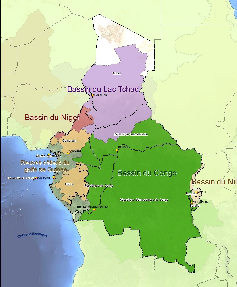
Central Africa is formed mainly of an enormous bloc of Precambrian rocks that crop out in an arc around a central sedimentary basin, separating it from the sedimentary Chad Basin to the north and the coastal sedimentary basin to the west.
Geological formations of Central Africa
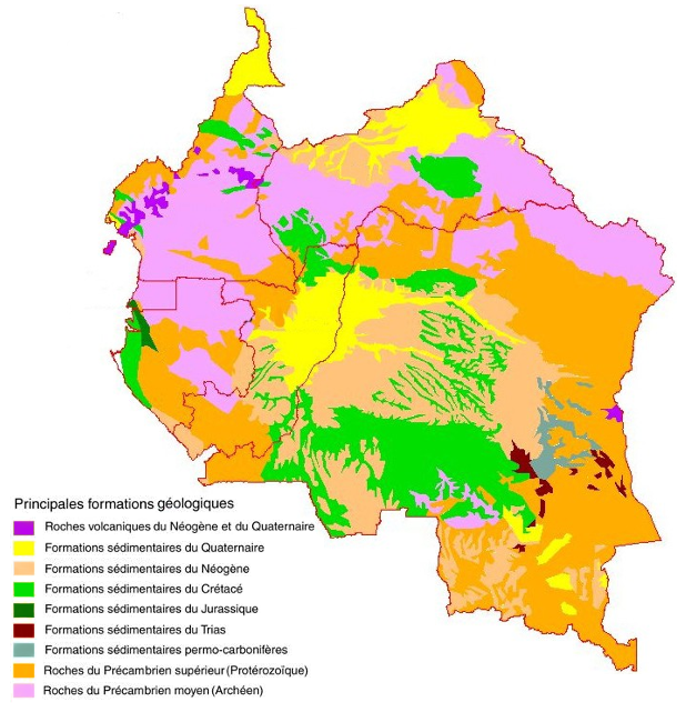
Cenozoic formations
The sedimentary formations comprise:
- Neogene (7) formations, between 26 and 1.8 millions years old, that cover the cretaceous formations in the centre of the basin. They are also found in the coastal sedimentary basin along the Gulf of Guinea.
- Quaternary and Holocene formations (8), less than 1.8 millions years old, that cover the two preceding formations around the confluence where the Ounagui and the Sangha meet the River Congo. They are most extensive in the Congo, and are also found in the coastal sedimentary basin, especially in the Ogooué delta.
- Volcanic formations dating back to the late Neogene, the Pleistocene and the Holocene (9). They are limited to western Cameroon to the west and the Albertine rift region, which is the western branch of the African-Arabian rift, to the east.
The Archean formations (1)
These formations are between 3.2 and 2.6 billion years old and cover the Monts du Chaillu on the Gabon-Congo border, the north of Gabon (Monts de Cristal and the Minkébé region), a large part of South Cameroon, the southern part of CAR and the northeast of DRC. Outcrops are also found in the south of DRC, around Kasaï. The rocks are mainly gneiss with more ancient inclusions dating back to 3.9 - 3.8 billion years ago.
Mesozoic formations
These are mainly sedimentary formations:
- Permian-Carboniferous formations, 350 to250 million years old, limited mainly to the eastern part of the Congo basin. They include some glacial sediments. There are also small formations of this age in northwestern Gabon, on the fringe of the coastal sedimentary basin
- Triassic formations that are 250 to 200 million years old, also located to the southeast of the central basin but covering only small areas.
- Cretaceous formations dating back 140 to 65 million years and covering a large part of the central basin and the coastal plain along the Gulf of Guinea
Proterozoic formations (2)
These are between 2.6 billion and 550 million years old. They include sedimentary formations and Archean rock that is generally strongly metamorphic and also, in some areas, intrusive rocks often in the form of inselbergs. The Proterozoic formations subdivide into several series that mainly cover the Paleoproterozoic (2.6-1.6 billion years ago) and the Neoproterozoic (1 billion to 550 million years ago). Together, these formations form an almost continuous arc around the edge of the Congo basin, with the Archean curving around it. The most extensive formations mainly cover the north, east and southeast of DRC. They are discontinuous in the Bas-Congo in DRC, form an east-west band through the centre of Gabon, and are also found in southeast Cameroon. The Proterozoic formations are rich in minerals, especially in areas where they are in contact with the Archean formations.
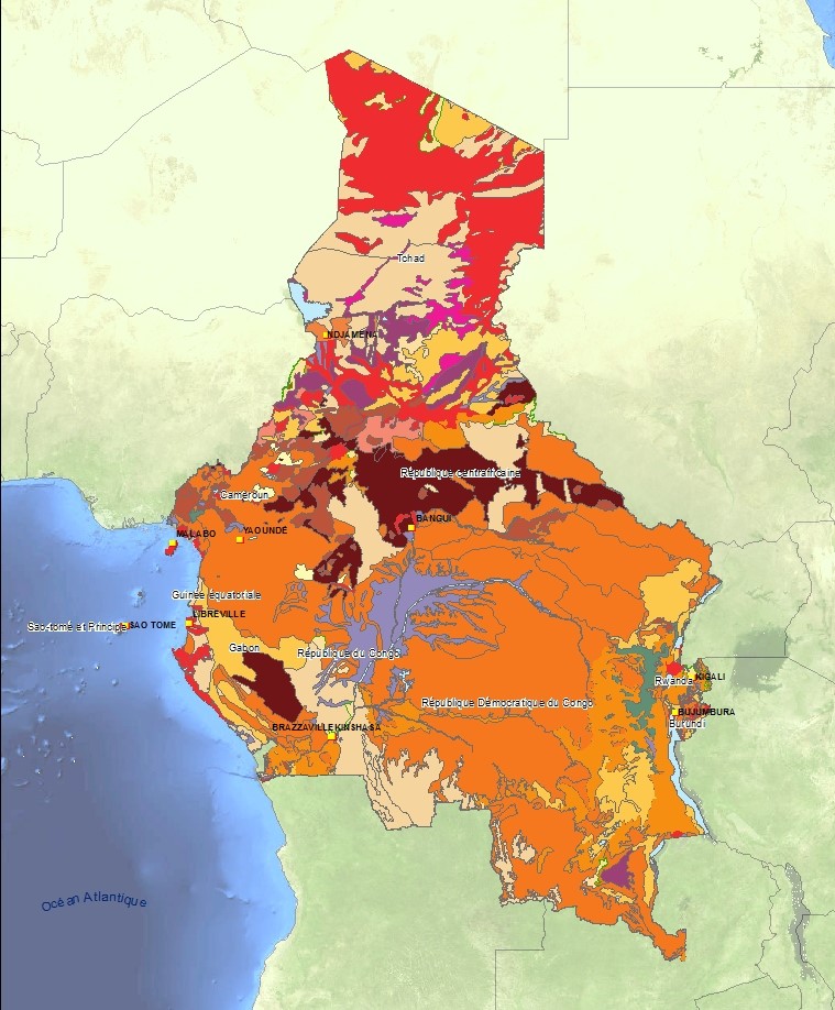
Soil Atlas of Africa
The Soil Atlas of Africa was published on 29 April 2013. The Atlas explains the origin and functions of the soils, describes the different types of soil and the usefulness for addressing local and global problems. It describes the main threats to the soils and the measure taken to protect Africa's soil resources.
The Soil Atlas of Africa is the result of collaboration between the European Union, the African Union, and the United Nations FAO, to support and encourage sustainable use of soil resources in Africa, and the Global Soil Partnership for Food Security.
http://esdac.jrc.ec.europa.eu/content/soil-map-soil-atlas-africa
Important information about the Atlas
- 98% of the calories consumed in Africa are from crops and livestock produced on African soils.
- Soil organic matter can store more than ten times its weight in water, thereby reducing the risk of flooding and protecting groundwater resources.
- African soils contain close to 200 gigatons of organic carbon, which is 2.5 times more than is contained in the continent's plants
- The soils of tropical rainforests are not naturally fertile; they require constant supply of organic matter from the natural plant cover. Deforestation breaks this cycle
- More than half of Africa's land surface is composed of sandy soils (22%), shallow stony soils (17%) and young, weakly developed soils (11%).
- Many of Africa's soils are severely degraded by erosion and excessive nutrient depletion. This explains their low productivity, mainly due to lack of plant nutrients, which are not adequately replenished by artificial fertilizers. Because of rural poverty, African farmers on average can only apply 10% of the fertilizer applied by farmers in the rest of the world