The second largest contiguous area of moist tropical forests in the world are in Central Africa where
they cover close to 2 million km2 (Mayaux et al. 1998). The Congo basin is mainly occupied by vast,
uninterrupted tracts of rainforest extending from the Gulf of Guinea to the Albertine Rift.
The central part of the basin has the largest tropical swamp forest in the world, and there
are two mountainous regions, in Cameroon and in eastern Democratic Republic of Congo (DRC).
Click here to see the list of forest tree species.
These tropical forests are central to international challenges around climate change and biodiversity conservation.
The Congo Basin, as the second largest tropical forest ecosystem, (after the Amazon basin) plays an important role
in the continental climate system and ensures the livelihood of 60 million people who live in or near the forest by
providing fuel, natural fibres and medicines, food and other non-woody forest products. They also have a social and
cultural function. These forests help to feed 40 million people in the nearby urban areas (Nasi et al. 2011).
For more information on the diversity and management of the Congo Basin forest ecosystems, their interaction with climate, etc.,
see OFAC's State of the Forests reports.
Mapping the forest ecosystems
Mapping and surveillance of forest cover are extremely important. The state of the forests affects the well-being of millions of people,
the regional and worldwide climate, and biodiversity. Precise knowledge of the forest's area, floristic composition and dynamics provide
information that is crucial for establishing and implementing environmental and economic policies. These essential roles are taken into account
in multilateral agreements on the environment such as the UNFCCC (United Nations Framework Convention on Climate Change),
policies such as REDD+ (Reducing Emissions from Deforestation and Forest Degradation)
that recognise the role of forests in the carbon cycle, and the CBD (Convention on Biological Diversity),
which recognises that forest habitat loss is a major cause of the decline in biodiversity.
Europe's FLEGT policy (Forest Law Enforcement, Governance and Trade) focuses on information on timber traceability and the legal aspects of logging.
For more information on the mapping of forest cover and these changes in Central Africa,
see Chapter 1 of the 2010 and 2013 OFAC State of the Forests.
Satellite images
The satellite images that are essential for monitoring forest cover are becoming increasingly free of charge and abundant.
There are numerous projects and institutions that provide these images.
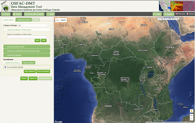
Central Africa has the Observatoire Satellital des Forêts d’Afrique Centrale (OSFAC), a direct partner of OFAC,
whose aim is to serve as an independent organisation for extending the use of satellite data and for monitoring environmental
changes in the Congo Basin. OSFAC intends to contribute to the COMIFAC Convergence Plan by supplying plant cover monitoring
data that are reliable and useful to managers and decision-makers.
To fulfil this goal and ensure the application of its products, OSFAC has also undertaken to use its regional
network to improve data availability and build capacity to use satellite data and their derivatives throughout Central Africa.
People from a wide range of disciplines have been addressing the question of mapping Central Africa for decades.
Published studies offer abundant data for a wide range of users, from protected area managers to policy-makers,
concession holders, etc. Unfortunately, the diversity of users’ needs, the different spatial coverages,
resolutions, types of plant relationships categorised (depending on vantage point) and the semantics used,
often lead to confusion and ambiguity in forest terminology.
This lack of standardisation in forest typology often compromises interoperability between cartographic
products and, hence, product validation, long-term monitoring of the forest cover, and the development
of future applications. This lessens the impact and credibility of the information supplied.
The OFAC Support Consortium is working on a new mapping initiative for the Congo Basin forest with a legend based
on a new typology that can accommodate the full diversity of the forests concerned, while ensuring that the maps
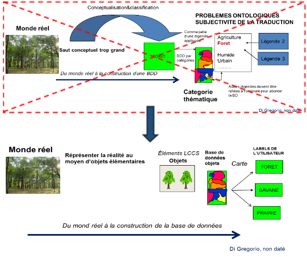
produced are interoperable. The methodological approach is no longer based on defining a set of classes in supervised
narrative manner, but rather on the use of real objects – biotic and abiotic elements with physiognomic properties
and characteristics – that are precisely defined using standardised syntax.
By applying simple rules to combine these objects in a hierarchy one can categorise all the land cover types observed on Earth,
however complex they may be.
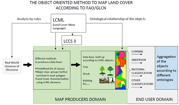
LCML language and LCCS3 software
For this purpose the common object-oriented language called Land Cover Meta Language (LCML) has been used since
it meets the ISO 19144-2 standard.
LCML is expressed as a UML metamodel that describes classes, objects, relations and attributes and can be used to describe land cover classification
systems according to their physiognomic aspects.
LCML is more than a mere language for harmonising classification systems. It is also a new, in-depth approach for
formalising the significance of land cover characteristics. Using the Land Cover Classification System v3 (LCCS 3)
software, forestlands and land cover in general, can easily be categorised according to users’ needs and desired applications.
The rigorous definition of the objects in the classification and the formalisation of the spatio-temporal
relations between objects and all the conditions describing each class, provide flexibility in the creation
of the different classes and precise translation of the class description into computer language.
It is up to the end user to combine these objects, configure their properties and attributes and create
a relational field connecting them according to the ontological framework that will best represent the
classes required for the topic in question (see Figure 2-2 below).
For more information on the LCML meta language or to download the LCCS3 software,
see (TERRA NOVA website or consult the FAO Global Land Cover Network website.
Regional legend for Congo Basin forests
The regional classification of Central African forests applied here is based on a preliminary inventory
of cartographic products and other classification systems already established for Central Africa,
in order to take advantage of all available knowledge.
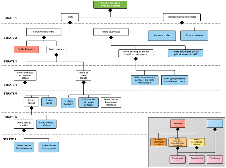
This legend is hierarchically structured to meet the needs of different stakeholders, decision-makers and managers.
It should be able to combine observation by remote sensing with groundwork such as forest inventories.
The categorised strata, from the simple binary forest/non-forest differentiation to the scale of a single tree stand are described here.
The criteria used here for categorising forest types are based solely on LCML elements.
These are indispensable criteria for typological categorisation, but other criteria can
be added to give a finer characterisation of local particularities or to address particular topics.
The decision was taken not to categorise vegetation by phytogeographic zone like Monod (1957),
Letouzey (1968) and Troupin (1966), nor by major chorological zone like White (1983).
These differentiations are not based on physiognomy, but rather often reflect endemic differences
in the floral composition. The different vegetation classes presented in these reference works
can be fitted into the hierarchical classification developed here.
In sum, we should no longer focus on the “label” (or name) given to the classes,
– each country has its own nomenclature, – but rather on the methodology used to
construct the classes, based on a rigorous definition of the basic elements and the relationship between them.
For a detailed description of the regional stratification of the forests of Central Africa
and the elements of the LCML used to describe each class, please download the typological note of the Forests of Central Africa
For a detailed description of the regional stratification of the forests of Central Africa
and the elements of the LCML used to describe each class, please download the typological note of the Forests of Central Africa.
Reference maps in the region
There are many maps available on land cover and forest types at local, national and regional scales.
The following table lists all the maps being used to make a harmonised regional map of the Congo Basin forests (in preparation).
The legends and their translations into LCML meta-language are available for download.
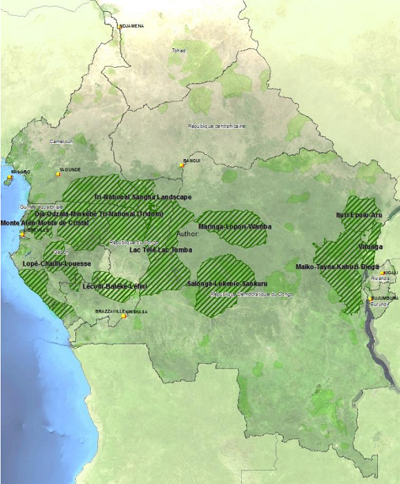
Ecological landscapes
Much forest resource management work has focused on 12 landscapes featuring high levels of biodiversity, in seven countries.
Together they cover 680,300 sq. km. Most of them span national borders and are covered by international agreements that
encourage cooperation in monitoring the environment and enforcing the law.
These landscapes were identified as suitable conservation targets at a workshop on prioritising conservation
in Central Africa, held in Libreville in 2000. The workshop was organised by the WWF and brought together more
than 160 biologists and socio-economists to evaluate the whole region. The 12 landscapes are listed as priority
conservation sectors because of their relative taxonomic importance, their overall integrity and the resilience
of the ecological processes they represent. In line with the principles of integrated large-scale land management
and conservation initiatives, each landscape is divided into its different management type zones,
which include protected areas, grassroots community natural resource management zones and mining zones.
In these zones the CARPE programme, among others,
is working to achieve sustainable natural resource management at the local level.