As a technical body under COMIFAC, the Observatory seeks to assist the Central African governments by supplying
all the information needed to establish coherent regional policies for sustainable management of the Congo Basin's forest ecosystems.
OFAC's work is focused on:
strengthening reference data collection capacity at the regional, national and local levels
imparting basic knowledge on the environment (geology, soil science, climate, vegetation, wildlife, habitats),
socio-economic aspects (population, development, institutions) and juridical issues
developing follow-up on subjects related to the natural and socio-economic environment,
to aid decision-making for the benefit of sustainable forest ecosystem management
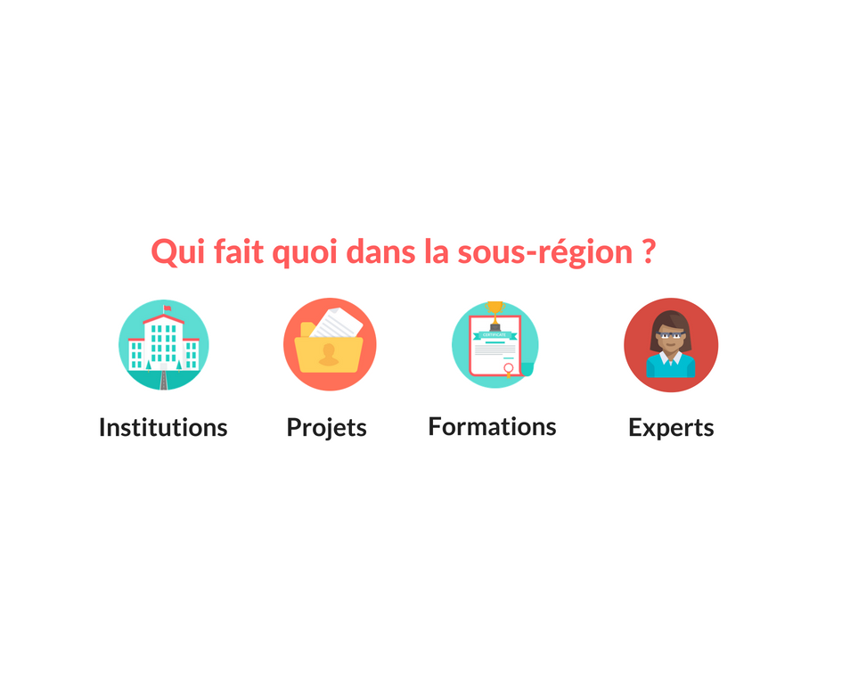
OFAC has developed a tool to inventory projects, experts, institutions and training connected with environmental management in Central Africa.
The tool comprises a series of databases, interrelated to allow the user to see who is doing what, where and how.
The databases feed a cartographic and analytical platform for recording and monitoring the implementation of initiatives in the Central African forest-environment sector.
This tool enables users to obtain a cross-cutting view of initiatives in COMIFAC countries,
to strengthen synergy among actors in the sector and to monitor the implementation and results of actions undertaken by PFBC partners.
Environmental data collecting
National data collecting
Every year, OFAC carries out campaigns to collect reference data “monitoring indicators” in the 10 COMIFAC countries.
These indicators, originally defined in 2008, were selected based on relevance, the nature of their variables, and ease of collection.
They are regularly revised to accommodate newly emerging issues and ensure synergy with other regional systems for collecting environmental data in Central Africa.
Data are collected for the following five topics: (i) forest cover, (ii) forest management, (iii)
legal and juridical framework, (iv) conservation and economic benefits of biodiversity, (v) climate change.
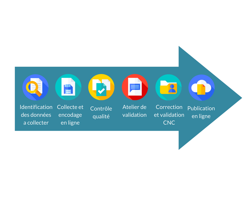
Collection of monitoring indicators in each country is organised by the COMIFAC National Coordination (CNC), headed by the country’s National Coordinator.
Data are collected by government bodies and at data gathering workshops attended by all the data providers and experts concerned in each country.
After the data have been collected, the OFAC team checks the quality, then the CNC holds a validation workshop where
the data supplied to OFAC is discussed with the experts and either validated or amended.
After the workshop, the National Coordinator validates the data on-line.
They are then published on the OFAC website which is available to all users.
The data are used, in particular, for writing national and regional executive summaries, issue papers and other publications.
Data that are not validated are nonetheless made available if they are of public interest;
they are explicitly marked and accompanied by a note explaining the data collection background.
Data collection in management sites
Logging concessions
OFAC and its partners have set up a database for monitoring logging concessions so as to collect
the data on timber abstraction under this type of logging permit in the COMIFAC countries. The data concern:
General information: on the concession, the recipient company and the acreage exploited.
Management and exploitation: processes, main management decisions and annual production statistics..
Social aspects: socio-economic, environmental and social studies of logging operations, measures taken for employees and local populations.
Biodiversity: status of biodiversity in the concession area, pressure on the ecosystem and biodiversity management strategy.
Protected areas
Working together with the BIOPAMA project, OFAC is constructing and hosting a regional information system on the protected areas of Central Africa.
This work involves several activities:
IMET, a regional tool for monitoring protected areas
To help improve management of the protected areas and meet conservations goals, the Biodiversity and
Protected Areas Management Programme (BIOPAMA) supports the development and use of "an integrated tool for the planning, monitoring and evaluation of the protected areas".
The tool, called IMET (Integrated Management Effectiveness Tool), fosters a proactive, results-based approach through tools that can describe and quantify the environment and its evolution.
By organising available information using predefined models to produce a Decision Support System,
IMET can contribute to the definition of benchmark levels, facilitate planning, analyse conservation status
and focus management efficiency assessments on conservation goals.
IMET was designed and developed to provide direct assistance to managers in the field or at the central level
(national protected areas agencies), to improve the efficiency of management for protected areas and to support biodiversity conservation in general.
Certain skills are required for analysing information on the IMET form and subsequently drawing up management proposals,
and this requires a new approach to the training of conservation coaches. COMIT (Coach Observatory Mission Information Toolkit)
has been created for this purpose. It is a pedagogical toolkit aimed at helping coaches carry out their mission and developing
the information system of the Biodiversity and Protected Areas Management (BIOPAMA) Programme. OFAC also trains and provides technical
assistance for training custodians in the COMIFAC countries.
Integrating the Digital Observatory for Protected Areas into the OFAC information system
The Digital Observatory for Protected Areas and its monitoring tools were set up under the BIOPAMA programme
and need to be incorporated into the OFAC system. This will entail developments on the computer side,
and proposals for institutional agreements with COMIFAC. The idea is to keep down the number of physical entities serving OFAC
and to ensure synergy among all biodiversity monitoring and management activities in Central Africa.
Partnerships with the national agencies responsible for protected areas
All these activities under the BIOPAMA programme or otherwise connected with monitoring and management of
the protected areas are implemented through memoranda of understanding between OFAC/COMIFAC, RAPAC (Network of Protected Areas in Central Africa)
and the national agencies responsible for managing protected areas. In 2016 three memoranda were signed, with:
Agence Congolaise de la Faune et des Aires Protégées (ACFAP, Congolese agency for wildlife and protected areas), Republic of Congo
Institut Congolais de Conservation de la Nature (ICCN, Congolese nature conservation institute), Democratic Republic of Congo
Agence Nationale des Parcs Nationaux (ANPN, National agency for national parks), Gabon
The aim is to establish an effective institutional and operational framework for supporting the collection
and analysis of data on the effectiveness of park management in Central Africa, at the local, national and regional levels
Monitoring permanent plots
The aim of the FAO-COMIFAC MRV project (MRV: measurement, reporting and verification) is capacity building
in Congo Basin countries on REDD+ issues in order to help these countries prepare for the future REDD+ system
and make good use of it for sustainably managing their forest ecosystems. COMIFAC governments currently consider
it the main pioneer underpinning the next stage of the REDD+ process. Under the MRV project, a database has been
created for the data from permanent vegetation monitoring plots.
The information is to be used for mapping the monitoring plots in the Congo Basin:
Identification: general information on the system, the management team, the goals, the state of the system,
its location, and the financial partners
Characteristics of the system: information on the plot, floral determination and forestry work
Data collection, archiving and exploitation: field data, (dendrometry, species determination, tree spacing, etc.),
measuring protocol, collection method, data management tools, use and exploitation of the data
The ultimate aim is for the scientists and managers of the permanent plots be included in the OFAC database
so as to exploit the information, develop synergy, harmonise measuring and monitoring methods and provide
the participating countries with the information needed for sustainable environmental management at the regional level.